
Heart Lake Hike
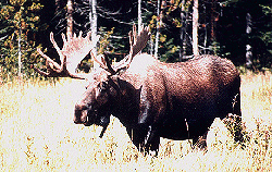 |
Bull Moose by Richard Feit
This information is provided by Robert Warren and John W. Uhler
This Page will be updated with hikes or areas that are not very well known or hikes with things to see along a particular trail. These items will be of interest to the backcountry hiker and day hiker that may want to see something new along the trail or know of some of the sights that may be of particular interest.
If you have any comments or suggestions, please let us know. We plan to add trails and hikes that will be of interest to the seasoned backcountry hiker or first time visitor. We will include tips and hints along the way.
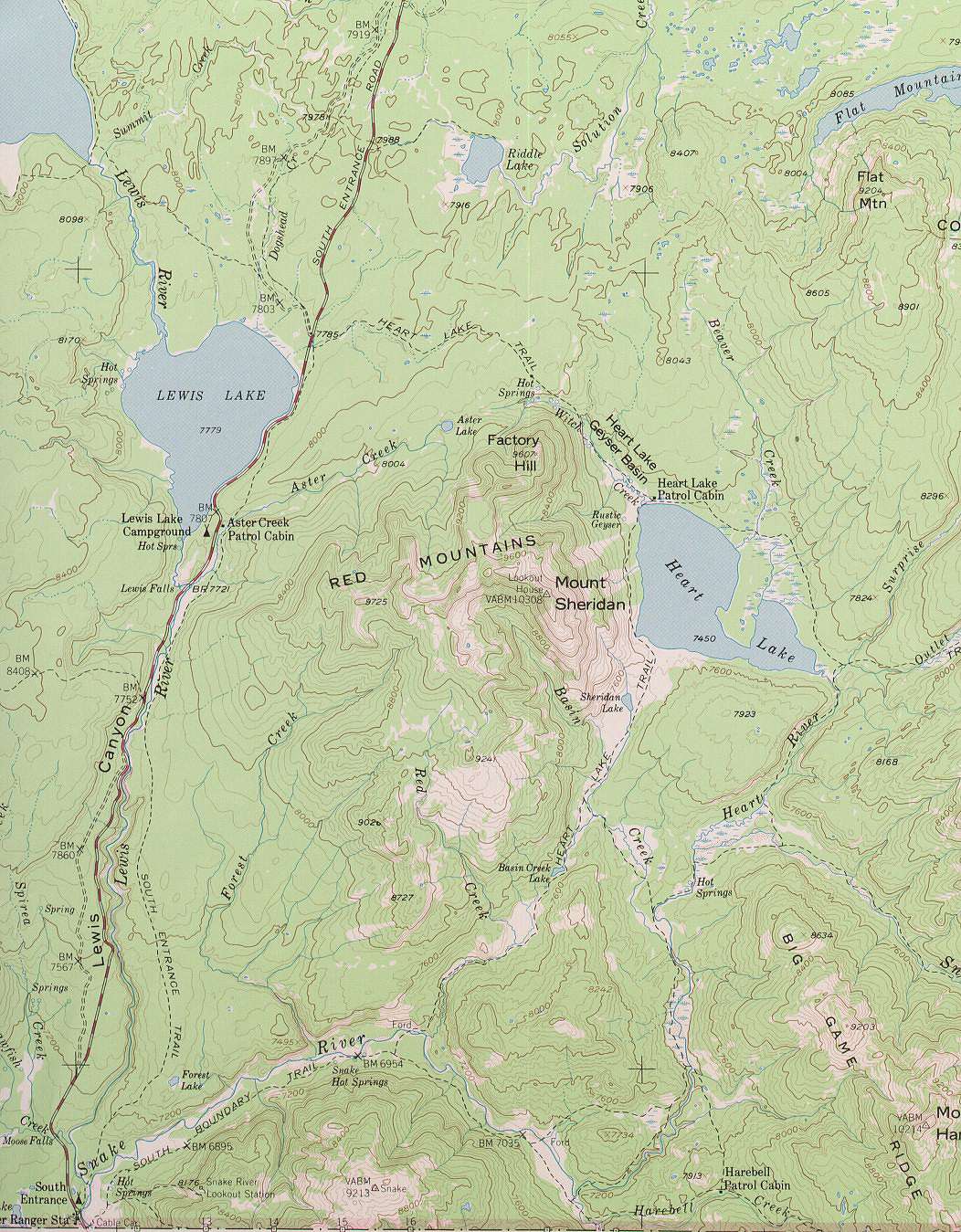
Heart Lake Trail - South of Grant Village Area
Trail description by Mark C. Marschall from his book "Yellowstone Trails"
"Starting at the Heart Lake Trailhead, the first 5.5 miles of trail climbs very gradually across a ravine and Heart Lake can be seen to the east. From here the trial drops down steeply, by way of several switch backs into the Witch Creek drainage. Several thermal features can be viewed up and down the creek. The water is extremely warm where bridges cross the creek.
The trail passes by a ranger's cabin when you reach the northeast shore of Heart Lake. As the trail continues south you pass by Rustic Geyser and some other thermal features to the west. The trail then leaves the shore, but continues to parallel the lake and the base of Mt. Sheridan. From here to the south end of Heart Lake, the trail yoyos up and down for about two miles, with no particular steep spots."
From the trailhead to the shore of Heart Lake is approximately eight miles.
This is bear country so talk or whistle and hike in groups of two or more.
The Heart Lake trail covers one of the most pristine areas in all of Yellowstone. This is a great overnight backcountry trip. The trailhead is found just north of Lewis Lake. Going northward it will be on the right hand (east) side of the road. The trail is used frequently so those wishing to make the overnight trip will want to be at the backcountry permit office early.
Let me begin by saying that the trail is beautiful. I think that this trail doesn't open until June or July 15th due to bear activity. All precautions for both hiking and camping in bear country should be strictly followed for your safety. A backcountry permit also needs to be obtained for overnight stays.
The trail is well marked and ascends slowly through some burnt forest area. This is a wonderful opportunity to obtain a first hand look at the process of life in Yellowstone with many young pine trees and a thick carpet of fresh young grasses and flowers amongst old, burnt and decaying logs. The trail breaks into the open approximately 5.5 miles from the trailhead. Heart Lake can now be seen to the east. For those not wishing to make the entire trip, this is a great stopping point. You now have a great view of Heart Lake, Factory Hill is to the south, and right below the trail is a small thermal area. Please remember to stay on the trail as thermal areas are always unpredictable and delicate.
From this open area the trail drops rapidly via switchbacks to the Witch Creek Drainage below. Mt. Sheridan, with its prominent fire-lookout tower can now be seen. There is a trail to the top for those wishing to gain a grand view of the park. This is a great place to begin seeing moose, deer, and elk. Continuing on the trail you will soon pass by the Heart Lake Ranger cabin at the northwest corner of the lake. This is a great place to stop for a sack-lunch and enjoy the tranquility of Heart Lake with its majestic guardian, Mt. Sheridan. From here, the trail forks with one spur going east (this spur will cross Beaver Creek and then continue eastward to join the Thoroughfare Trail running north and south along the east shore of Yellowstone Lake), the other spur goes south (this spur will take you, at a distance, along the west shore of Heart Lake, and on to the southern portion of the park). For those going south, you will pass the junction to Rustic Geyser. Take some time and go and view this thermal basin.
Continuing south, the trail makes some short ups and downs until reaching the south shore. There are no real steep spots. This is a wonderful hike. Remember, you will have to climb back up those switchbacks, but as stated in the Seven Mile Hole report, take your time, breathe steadily, and look back occasionally (not that you won't be able to help it). Perhaps Heart Lake would fittingly receive its name because it will always hold a special place in your heart, constantly calling you to return.
Please don't take pets - it is against park regulations to take pets on trails and into the backcountry.
Not all campsites allow a fire. Ours was one of those. It would have been nice to have a fire to sit around and chat and look at the stars and breathe the fresh air and all of that fun Yellowstone stuff, but the seclusion was nice (and we were also bone tired!).
About the pets, a campsite about 1 mile north of ours had a dog. It disturbs the peace of the wildlife and also the experience of other people.
It was mid-September when we started our trip to Heart Lake. The weather (temperatures and all) could not have been better. The lake was at a good level, and wildlife were abundant. We saw deer, coyotes, a Pika (Rock Rabbit, a real rarety), and some moose, and also cutthroat trout on the end of our lines, some ducks, geese, and my favorite bird because of this hike, some loons.
Let me report on some wildlife experiences unchallenged. On our hike out in the morning there was a light fog over the lake. The lake was as smooth as a plate of glass, undisturbed in any way. As I looked out over the water the shrill of a loon from across the lake pierced the morning air. It was AWESOME!
As we hiked out, we came across the campsite with the dog and also three of the largest bull moose we had ever seen. We talked with the members of the camp who had been awake all night, outside their tents, due to the sparring of the bull moose. We got some great pictures.
While fishing Heart Lake, we caught two trout in the #4 range on a muddler minnow and wooley bugger. We had a great time and would recommend the hike and area to anyone interested.
Tread lightly and have Fun! Happy Trails!
You can contact Robert at robbiedwarren@gmail.com
 |
| Yellowstone National Park Milage | ||||||
|---|---|---|---|---|---|---|
| Canyon | Grant | Lake | Mammoth | Old Faithful | Roosevelt | |
| Canyon | -- | 40 | 17 | 33 | 42 | 19 |
| Grant | 40 | -- | 24 | 73 | 19 | 59 |
| Lake | 17 | 24 | -- | 49 | 38 | 36 |
| Mammoth | 33 | 73 | 49 | -- | 51 | 18 |
| Old Faithful | 42 | 19 | 38 | 51 | -- | 61 |
| Roosevelt | 19 | 59 | 36 | 18 | 61 | -- |
Milage Chart from Gardiner, Montana
Yellowstone National Park's North Entrance
| North Entrance at Gardiner, Montana | Less than a mile |
| Mammoth Hot Springs | 5 miles |
| Tower | 23 miles |
| Norris Geyser Basin | 26 miles |
| Canyon | 38 miles |
| Madison | 40 miles |
| Northeast Entrance | 52 miles |
| Silver Gate, Montana | 53 miles |
| West Entrance | 54 miles |
| West Yellowstone, Montana | 54 miles |
| Yellowstone Lake | 54 miles |
| Old Faithful | 56 miles |
| Cooke City, Montana | 56 miles |
| West Thumb | 73 miles |
| East Entrance | 81 miles |
| South Entrance | 95 miles |
| Cody, Wyoming | 134 miles |
| Jackson Hole, Wyoming | 160 miles |

| Yellowstone National Park WebCams | |||||||
|---|---|---|---|---|---|---|---|
| Old Faithful Live | All Old Faithful | Old Faithful Static | Old Faithful VC | North Entrance | Mt Washburn | Mammoth | YVO WebCam |
| Entrance Cities and Gateway Towns | |||
|---|---|---|---|
| Gardiner, Montana | Silver Gate, Montana | West Yellowstone, Montana | Cooke City, Montana |
| Livingston, Montana | Cody, Wyoming | Jackson Hole, Wyoming | Yellowstone National Park |

| Links | |
|---|---|
| The Great Outdoors Net | Great Outdoor Recreational Places |
| Gardiner, Montana | West Yellowstone, Montana |
 |  |