
Yellowstone National Park Picnic Areas
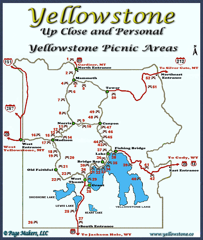
There are 52 picnic areas in Yellowstone National Park. A list of the picnic areas as well as tables, grills, and restrooms are listed. Below that is an Image Map of the picnic area locations. Click on a picnic area name or number (on the image map below the listing) for additional information, pictures, and videos. There are tables at every picnic area, and most have restrooms. Not all picnic areas have grills for cooking. No open fires are allowed at any picnic area, cooking is allowed on the grills or a campstove. No fuel is provided, most visitors utilize campstoves or charcoal. No overnight camping is allowed in any picnic area in Yellowstone. It is a good idea to bring some type of hand sanitizer as not all restrooms provide it or they frequently run out.
| Picnic Areas - Yellowstone National Park | ||||||||||
|---|---|---|---|---|---|---|---|---|---|---|
| No. | Area | Tables | Grills | RR | X | No. | Area | Tables | Grills | RR |
| 1 | Arch Park | 8 | 1 | 1 | X | 27 | Snake River | 15 | 8 | 1 |
| 2 | Gardner River | 4 | 0 | 1 | X | 28 | Grant Village | 17 | 12 | 1 |
| 3 | Albright | 4 | 0 | 2 | X | 29 | West Thumb | 5 | 0 | 1 |
| 4 | Mammoth | 2 | 0 | NB | X | 30 | Hard Road to Travel | 3 | 0 | 0 |
| 5 | Lava Creek | 5 | 0 | 1 | X | 31 | Pumice Point | 3 | 0 | 2 |
| 6 | Sheepeater Cliff | 5 | 0 | 1 | X | 32 | Fisherman's Access | 2 | 0 | 0 |
| 7 | Appolinaris Spring | 6 | 0 | 2 | X | 33 | Spruce-Fir Exhibit | 4 | 0 | 0 |
| 8 | Beaver Lake | 9 | 0 | 1 | X | 34 | Sand Point | 18 | 0 | 4 |
| 9 | Norris Meadows | 16 | 4 | 1 | X | 35 | Gull Point | 21 | 0 | 1 |
| 10 | Virginia Cascasdes | 6 | 0 | 2 | X | 36 | Bridge Bay | 23 | 3 | 1 |
| 11 | Gibbon Meadows | 9 | 0 | 1 | X | 37 | Lake Village | 2 | 0 | 0 |
| 12 | Caldera Rim | 3 | 0 | 1 | X | 38 | Fishing Bridge | 6 | 0 | 0 |
| 13 | Iron Springs | 5 | 0 | 1 | X | 39 | Steamboat Point | 4 | 0 | 1 |
| 14 | Gibbon Falls | 7 | 0 | 0 | X | 40 | Sedge Bay | 1 | 0 | 1 |
| 15 | Tuff Cliff | 3 | 0 | 1 | X | 41 | Sylvan Lake | 3 | 0 | 1 |
| 16 | Madison River | 9 | 0 | 1 | X | 42 | Eleanor Lake | 8 | 0 | 1 |
| 17 | Madison Junction | 14 | 0 | 1 | X | 43 | Le Hardy | 2 | 0 | 0 |
| 18 | Firehole River | 12 | 0 | 1 | X | 44 | Cascade | 6 | 0 | 1 |
| 19 | Nez Perce | 10 | 3 | 1 | X | 45 | Nez Perce Ford | 17 | 0 | 1 |
| 20 | Whiskey Flats | 13 | 0 | 1 | X | 46 | Otter Creek | 8 | 0 | 0 |
| 21 | East Lot | 7 | 2 | 1 | X | 47 | Chittenden Bridge | 4 | 0 | 0 |
| 22 | Spring Creek | 10 | 2 | 1 | X | 48 | Cascade Lake Trail | 16 | 5 | 1 |
| 23 | DeLacey Creek | 9 | 0 | 1 | X | 49 | Dunraven Road | 12 | 0 | 1 |
| 24 | East Divide | 14 | 0 | 1 | X | 50 | Yellowstone | 9 | 4 | 1 |
| 25 | Lewis Lake | 9 | 0 | 2 | X | 51 | Soda Butte Creek | 4 | 0 | 1 |
| 26 | Cave Falls | 3 | 0 | 1 |
X | 52 | Warm Creek | 7 | 0 | 1 |
| = Handicapped Accessible / NB = Nearby / RR* = Restrooms |
|
Click on an Area or Town for more Information
| Yellowstone National Park Milage | ||||||
|---|---|---|---|---|---|---|
| Old Faithful | Grant | Lake | Canyon | Mammoth | Roosevelt | |
| Old Faithful | 19 | 38 | 42 | 51 | 61 | |
| Grant | 19 | 24 | 40 | 73 | 59 | |
| Lake | 38 | 24 | 17 | 49 | 36 | |
| Canyon | 42 | 40 | 17 | 33 | 19 | |
| Mammoth | 51 | 73 | 49 | 33 | 18 | |
| Roosevelt | 61 | 59 | 36 | 19 | 18 | |
Milage Chart from Gardiner, Montana
Yellowstone National Park's North Entrance
| North Entrance at Gardiner, Montana | Less than a mile |
| Mammoth Hot Springs | 5 miles |
| Tower | 23 miles |
| Norris Geyser Basin | 26 miles |
| Canyon | 38 miles |
| Madison | 40 miles |
| Northeast Entrance | 52 miles |
| Silver Gate, Montana | 53 miles |
| West Entrance | 54 miles |
| West Yellowstone, Montana | 54 miles |
| Yellowstone Lake | 54 miles |
| Old Faithful | 56 miles |
| Cooke City, Montana | 56 miles |
| West Thumb | 73 miles |
| East Entrance | 81 miles |
| South Entrance | 95 miles |
| Cody, Wyoming | 134 miles |
| Jackson Hole, Wyoming | 160 miles |
* * * Cave Falls Campground * * *
US Forest Service Campground outside the southwest corner of Yellowstone near the Bechler Ranger Station and Cave Falls.


| Yellowstone National Park WebCams | |||
|---|---|---|---|
| All WebCams | East Entrance | Mammoth | Mount Washburn |
| North Entrance | Old Faithful Live | West Entrance | YVO WebCam |
| All WebCams |
|---|
| All U.S. National Parks, National Monuments, National Recreational Areas, and National Seashore WebCams |
| Entrance Cities and Gateway Towns | |||
|---|---|---|---|
| Gardiner, Montana | Silver Gate, Montana | West Yellowstone, Montana | Cooke City, Montana |
| Livingston, Montana | Cody, Wyoming | Jackson Hole, Wyoming | Yellowstone National Park |

| Links | |
|---|---|
| The Great Outdoors Net | Great Outdoor Recreational Places |
| Gardiner, Montana | West Yellowstone, Montana |
 |  |