
Soda Butte Cone Yellowstone National Park
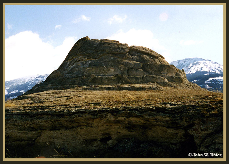 |
Soda Butte Cone Yellowstone National Park © Page Makers, LLC
The Soda Butte Cone is located in the Northeastern Area of Yellowstone National Park
This usage which is of an undeniable prospector origion, is just as certainly based on a false premise.
Soda Butte, a striking hot spring cone about two and a half miles above the mouth of Soda Butte Creek, is the feature that suggested this place name. It was given by A. Bart Henderson, who had descended Cache Creek to the Lamar River with a prospecting party when he made this entry in his diary:
Camped on East Fork, south side. Just opposite camp a small creek empties into river. One mile up this creek is a very singular butte, some 40 feet high, which has been formed by soda water. We gave the cone the name of Soda Butte, & the creek the name of Soda Butte Creek.1
Henderson was never an accurate observer, and in this case he ran true to form; Soda Butte was twice as far from his camp but only half as high as he made it, and it was not formed of soda ash (sodium carbonate) as he thought. It is really a deposit of travertine (calcium carbonate) — the same as Mammoth Hot Springs.
Regardless of the chemical inaccuracy of Soda Butte, it has staying power as a place name. The map that recorded the Hayden Survey's 1871 season in the Park designated Soda Butte Creek as "Sulphur Spring Creek," and Barlow's map used "Buffalo Creek," but neither survived. By the time the Geological Survey took over mapping in the Park, common usage had decided the issue, and all official maps from 1885 to the present have labeled the hot spring cone "Soda Butte" and the adjacent stream "Soda Butte Creek."
There have been a number of spin-offs from the basic place name, but none have survived. Superintendent Norris used the term "Soda Butte Medicinal Springs" for the seepage of warm water on the creek side of Soda Butte in 1879, and he shortened that to "Soda Butte Springs" in 1880.2 Although Norris was lavish in his praise of the springs at Soda Butte, they were not prominent enough to attract further notice.
An officer who accompanied General Philip H. Sheridan on his monumental junket across Yellowstone Park in 1881 recorded another name that has not survived — "Soda Butte Lake." From his remarks, "It is said that the miners of Cook City took ten tons [of fish] out of it last fall by drawing the lake and using nets, and dried them for winter's use,"3 we recognize present Trout Lake.
Also in the limbo of lost place names is "Soda Butte Mail Station," established in 1884 on the road to Cooke City, and the "Soda Butte Station." The latter was occupied by a detachment of soldiers in 1886 and continued in use as a ranger station until the building was moved to the Buffalo Ranch prior to 1938 (although the station was still shown at Soda Butte on the 1954 revision of the Park-wide map).
The last of the Soda Butte names that failed to survive was "Soda Butte Canyon." The United States Geographic Board published a decision on May 7, 1930, assigning the name "Soda Butte Canyon" to the entire valley of Soda Butte Creek from the Soda Butte nearly to Silver Gate.4 Another decision in 1933 limited Soda Butte Canyon to a small, roadside gorge a mile above Round Praire. But that was later changed to Ice Box Canyon, and the Soda Butte Canyon name never got on the map.5
This information is from: "Yellowstone Place Names - Mirrors of History by Aubrey L. Haines (Yellowstone Historian), pp 57 - 58.
Footnotes
1 A. Bart Henderson, Journal of the Yellowstone Expedition of 1866 Under Captain Jeff Standifer ... Also the Diaries Kept by Henderson During His Prospecting Journeys in the Snake, Wind River, and Yellowstone Country During the Years 1866-72. Transcription by Granville Stuart, Coe Collection Item No. 452, Beinecke Library, Yale University, New Haven. p. 93 (July 23, 1870).
2 Philetus W. Norris, Report Upon the Yellowstone National Park, to the Secretary of the Interior, for the Year 1879 (Washington: Government Printing Office, 1880), pp. 23 & 30. Also, Annual Report of the Superintendent of the Yellowstone National Park, to the Secretary of the Interior, for the Year 1880 (Washington: Government Printing Office, 1881), map.
3 Philip H. Sheridan, Report of Lieut. Col. James F. Gregory, "Report of Lieut. General P. H. Sheridan, Dated September 20, 1881, of His Expedition Through the Big Horn Mountains, Yellowstone National Park, Etc. (Washington: Government Printing Office, 1882), p. 18.
4 Decisions of the United States Geographic Board, Yellowstone National Park (Washington: Government Printing Office, 1930), p. 21.
5 Decisions of the United States Board on Geographic Names, July 1, 1936 two June 2nd, 1937 (Washington: Government Printing Office, 1937), p. 15.

Soda Butte Cone Yellowstone National Park © Page Makers, LLC
| Other Yellowstone Place Names | |
|---|---|
| Electric Peak | Sepulcher Mountain |
| Soda Butte | Yellowstone |
For more information and pictures, check us out on  FaceBook

| Yellowstone National Park WebCams | |||||||
|---|---|---|---|---|---|---|---|
| Old Faithful Live | All Old Faithful | Old Faithful Static | Old Faithful VC | North Entrance | Mt Washburn | Mammoth | YVO WebCam |
| Entrance Cities and Gateway Towns | |||
|---|---|---|---|
| Gardiner, Montana | Silver Gate, Montana | West Yellowstone, Montana | Cooke City, Montana |
| Livingston, Montana | Cody, Wyoming | Jackson Hole, Wyoming | Yellowstone National Park |

| Links | |
|---|---|
| The Great Outdoors Net | Great Outdoor Recreational Places |
| Gardiner, Montana | World Humanity |