
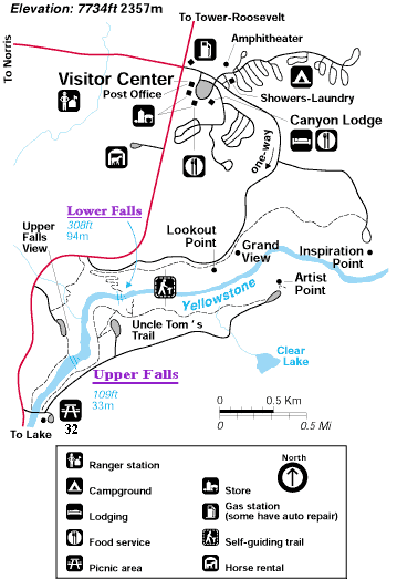
Lower Falls of the Yellowstone
Yellowstone National Park
Lower Falls of the Yellowstone - of the Grand Canyon of the Yellowstone
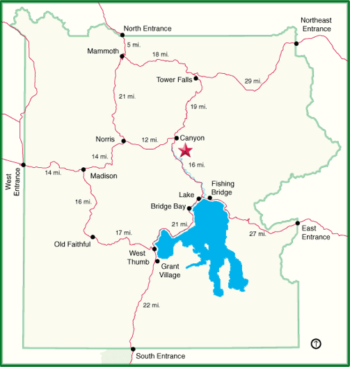
| Lower Falls is located in the eastern central portion of Yellowstone National Park in the Canyon area.
"This cataract, long believed to be the park's tallest at 308 feet, is also one of the great waterfalls of the North America continent. It has had more words written about it than any other park waterfall. Nearly half the historic visitor reactions to Yellowstone waterfalls we collected were written about Lower Falls and its upstream campanion, Upper Falls. A note in William Clark's journal of his famous 1802-07 expedition stated that the Yellowstone River had "a considerable fall" somewhere in the mountains. Clark then wrote "No" after it, an indication that even he did not believe what he had heard. But the waterfall was real. Native Americans had probably seen it for years. We may never know what Euro-Americans first looked upon it, but French fur trapper Baptiste Ducharme claimed to have seen Lower Falls in 1824, 1826, and 1839. Explorers Jim Bridger and James Gemmell visited the falls in 1846. In 1851, Bridger drew a map for Father Jean DeSmet that showed "Falls 250 feet." Traveling prospectors of the 1860s brought stories back to the Montana Territory of a huge waterfall on the Yellowstone River that appeared in frontier newspapers. One such article claimed the falls was "thousands of feet" high while another said it was 1,500 feet and called it "the most sublime spot on earth." The 1869 Folsom expedition gave the name to both of the great Yellowstone waterfalls, from their positions on the river, and attempted to measure their heights. Their map carried the notation "Lower Falls 350 feet." However, early visitors also referred to it as the "Great Fall" or "Grand Fall" of the Yellowstone. A notch in the riverbed causes the green color of the water that extends partway down from the top of the falls. This allows the river to retain some of its green color instead of immediately breaking into spray. In 1872 Dr. A.C. Peale mentioned this green streak was present at that time." |
| Lower Falls of the Yellowstone Information | |
|---|---|
| Location | 44° 43' 12.39" N / 110° 28' 47.45" W (Artist Point Parking area - Elev. 7667') |
| Fall Type | Plunge |
| Height | 308 feet |
| Width | 70 - 80 feet at the crest of the falls |
| Stream | Yellowstone River |
| Flow | 63,500 gallons a second in spring ~ 5,000 gallons a second in fall |
| Access | About 1.5 miles south of Canyon Village |
| The above information is from the book "Yellowstone Waterfalls and their Discovery" by Paul Rubinstein, Lee H. Whittlesey, and Mike Stevens. |
 |
 |

Wildlive Videos
Yellowstone Wildlife Videos
Geysers and Thermals
Yellowstone Geysers and Thermal Videos
| Yellowstone Geyser and Thermal Videos | |
|---|---|
| Beehive Geyser Eruption | Old Faithful with Bison |
| Beehive Geyser Eruption Two | Pocket Basin |
| Fan and Mortar | Roaring Mountain |
| Grand Geyser | Rocket and Grotto |
| Old Faithful One | West Thumb |
Waterfalls
Yellowstone Waterfall Videos
| Yellowstone Waterfall Videos | ||
|---|---|---|
| Cave Falls | Mesa Falls | Undine Falls |
| Gibbon Falls | Rustic Falls | Upper Falls |
| Lower Falls | Tower Fall | Wraith Falls |


| Yellowstone National Park WebCams | |||
|---|---|---|---|
| Old Faithful Live | All Old Faithful | Old Faithful Static | Old Faithful VC |
| North Entrance | Mt Washburn | Mammoth | YVO WebCam |
| Entrance Cities and Gateway Towns | |||
|---|---|---|---|
| Gardiner, Montana | Silver Gate, Montana | West Yellowstone, Montana | Cooke City, Montana |
| Livingston, Montana | Cody, Wyoming | Jackson Hole, Wyoming | Yellowstone National Park |

| Links | |
|---|---|
| The Great Outdoors Net | Great Outdoor Recreational Places |
| Gardiner, Montana | West Yellowstone, Montana |
 |  |